

Mühltalrundweg


- pets allowed
- All weather
- Flatly
Interactive elevation profile
Create PDF
Tour-Details
Path number: 21
Starting place: 4121 Altenfelden
Destination: 4121 Altenfelden
duration: 4h 7m
length: 13,7 km
Altitude difference (uphill): 383m
Altitude difference (downhill): 379m
Lowest point: 353m
Highest point: 626m
difficulty: easy
condition: easy
panoramic view: Individual Views
Paths covering:
Asphalt, Hiking trail, Other
powered by TOURDATA
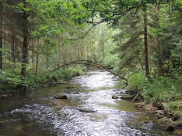
Beautiful circular route into the Große Mühltal valley with easy climbs, suitable for all hikers.
ROUTENVERLAUF: From the market square via Mairhof, Reiwies and Bauer auf der Oedt to Hörhag. The route continues via Unteredt and Beerau to the neighbouring municipality of Kirchberg to Mayrhof and Grub. The route returns via Große Mühltal, Neundling and Blumau to Altenfelden.VIEWPOINTS: Reinwies hill, Bauer auf der Oedt
SIGHTSHIPS: Ebenmühle, Rabenstein, Geißkirche, Schwarze Kuchl
With the free outdooractive app, you can hike the trail using navigation.
- All weather
- Pets allowed
- Spring
- Summer
- Autumn
Please get in touch for more information.
Veldenstraße 3
4121 Altenfelden
Phone +43 5 07263 - 200
E-Mail boehmerwald@muehlviertel.at
Web www.muehlviertel.at
https://www.muehlviertel.at
Interactive elevation profile
Create PDF
Tour-Details
Path number: 21
Starting place: 4121 Altenfelden
Destination: 4121 Altenfelden
duration: 4h 7m
length: 13,7 km
Altitude difference (uphill): 383m
Altitude difference (downhill): 379m
Lowest point: 353m
Highest point: 626m
difficulty: easy
condition: easy
panoramic view: Individual Views
Paths covering:
Asphalt, Hiking trail, Other
powered by TOURDATA