

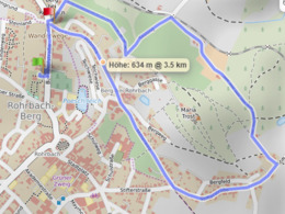
Lauf- und Wanderstrecke Bramel Runde


- Flatly
Interactive elevation profile
Create PDF
Tour-Details
Starting place: 4150 Rohrbach-Berg
Destination: 4150 Rohrbach-Berg
duration: 1h 9m
length: 4,0 km
Altitude difference (uphill): 95m
Altitude difference (downhill): 82m
Lowest point: 595m
Highest point: 651m
difficulty: medium
condition: medium
panoramic view: Individual Views
Paths covering:
Asphalt, Gravel, Hiking trail
powered by TOURDATA
Beautiful tour with a great view from the Liberation Cross.
Length: 4.24 kmVILLA sinnenreich > Pfaffenberg > Klingreith > Stifterstraße > Mitterweg > VILLA sinnenreich
With the free outdooractive app, you can walk the trail using navigation.

Most economical season
- Spring
- Summer
- Autumn
Please get in touch for more information.
Stadtplatz 1
4150 Rohrbach-Berg
Phone +43 7289 6255
E-Mail stadt@rohrbach-berg.ooe.gv.at
Interactive elevation profile
Create PDF
Tour-Details
Starting place: 4150 Rohrbach-Berg
Destination: 4150 Rohrbach-Berg
duration: 1h 9m
length: 4,0 km
Altitude difference (uphill): 95m
Altitude difference (downhill): 82m
Lowest point: 595m
Highest point: 651m
difficulty: medium
condition: medium
panoramic view: Individual Views
Paths covering:
Asphalt, Gravel, Hiking trail
powered by TOURDATA