

Lauf- und Wanderstrecke "Ria di, g'spir di-Runde"


- Flatly
Interactive elevation profile
Create PDF
Tour-Details
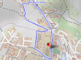
Starting place: 4150 Rohrbach-Berg
Destination: 4150 Rohrbach-Berg
duration: 0h 48m
length: 2,8 km
Altitude difference (uphill): 56m
Altitude difference (downhill): 55m
Lowest point: 595m
Highest point: 641m
difficulty: medium
condition: medium
panoramic view: No view
Paths covering:
Asphalt
powered by TOURDATA
Short running route without major inclines.
Length: 2.61 kmVilla Sinnenreich > Bahnhofstraße > Angerweg > Erlengrund > Villa Sinnenreich
With the free outdooractive app, you can walk the trail using navigation.

Most economical season
- Spring
- Summer
- Autumn
Please get in touch for more information.
Stadtplatz 1
4150 Rohrbach-Berg
Phone +43 7289 6255
E-Mail stadt@rohrbach-berg.ooe.gv.at
Interactive elevation profile
Create PDF
Tour-Details
Starting place: 4150 Rohrbach-Berg
Destination: 4150 Rohrbach-Berg
duration: 0h 48m
length: 2,8 km
Altitude difference (uphill): 56m
Altitude difference (downhill): 55m
Lowest point: 595m
Highest point: 641m
difficulty: medium
condition: medium
panoramic view: No view
Paths covering:
Asphalt
powered by TOURDATA