

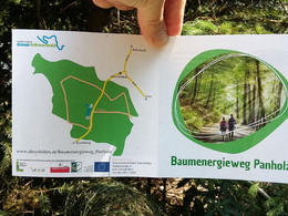
Baumenergieweg Panholz


- All weather
- Suitable for families
- Suitable for pushchairs
- Flatly
Interactive elevation profile
Create PDF
Tour-Details
Starting place: 4121 Altenfelden
Destination: 4121 Altenfelden
duration: 0h 45m
length: 2,5 km
Altitude difference (uphill): 29m
Altitude difference (downhill): 33m
Lowest point: 554m
Highest point: 591m
difficulty: very easy
condition: very easy
panoramic view: No view
Paths covering:
Asphalt, Hiking trail
powered by TOURDATA
The tree is shrouded in myth. Rooted in the earth and striving towards the sky, it symbolises strength.
With the free outdooractive app, you can hike the trail using navigation.
further information:
- Flatly
Details - hiking
- themed path
- educational path
Parking
- Parking space: 20
- Bus parking space: 1
- All weather
- Suitable for groups
- Suitable for pushchairs
- Suitable for teenagers
- Suitable for families
- Suitable for children
- Spring
- Summer
- Autumn
- Early winter
Please get in touch for more information.
Veldenstraße 3
4121 Altenfelden
Phone +43 7282 5555 - 15
E-Mail gemeindeamt@altenfelden.at
Web www.baumenergieweg.at/
https://www.baumenergieweg.at/
You can also visit us on
Visit us on Facebook Visit us on Instagram Visit our videochannel on YouTubeInteractive elevation profile
Create PDF
Tour-Details
Starting place: 4121 Altenfelden
Destination: 4121 Altenfelden
duration: 0h 45m
length: 2,5 km
Altitude difference (uphill): 29m
Altitude difference (downhill): 33m
Lowest point: 554m
Highest point: 591m
difficulty: very easy
condition: very easy
panoramic view: No view
Paths covering:
Asphalt, Hiking trail
powered by TOURDATA