

Höhenweg


- All weather
- Flatly
- Possible accommodation
Interactive elevation profile
Create PDF
Tour-Details
Path number: J3
Starting place: 4172 St. Johann am Wimberg
Destination: 4172 St. Johann am Wimberg
duration: 1h 12m
length: 4,2 km
Altitude difference (uphill): 84m
Altitude difference (downhill): 84m
Lowest point: 714m
Highest point: 807m
difficulty: easy
condition: easy
panoramic view: Great panorama
Paths covering:
Asphalt, unfixed, Hiking trail
powered by TOURDATA
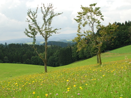
Höhenweg,
as the name suggests, you move above the rooftops of St. Johann.
A beautiful short hiking trail that is also suitable for children.
With the free outdooractive app, you can hike the trail using navigation.
- All weather
- Suitable for groups
- Suitable for schools
- Suitable for single travelers
- Suitable for friends
- Spring
- Summer
- Autumn
- Early winter
- Deep winter
Please get in touch for more information.
St. Johann 10
4172 St. Johann am Wimberg
Phone +43 7217 7155
E-Mail gemeinde@stjohannamwimberg.at
Web www.stjohannamwimberg.at
https://www.stjohannamwimberg.at
You can also visit us on
Visit us on Facebook Visit us on Instagram Visit our videochannel on YouTubeInteractive elevation profile
Create PDF
Tour-Details
Path number: J3
Starting place: 4172 St. Johann am Wimberg
Destination: 4172 St. Johann am Wimberg
duration: 1h 12m
length: 4,2 km
Altitude difference (uphill): 84m
Altitude difference (downhill): 84m
Lowest point: 714m
Highest point: 807m
difficulty: easy
condition: easy
panoramic view: Great panorama
Paths covering:
Asphalt, unfixed, Hiking trail
powered by TOURDATA