

Standardloipe


- Flatly
Interactive elevation profile
Create PDF
Tour-Details
Path number: 9
Starting place: 4154 Kollerschlag
Destination: 4154 Kollerschlag
duration: 1h 30m
length: 11,0 km
Altitude difference (uphill): 98m
Altitude difference (downhill): 101m
Lowest point: 652m
Highest point: 723m
difficulty: medium
condition: medium
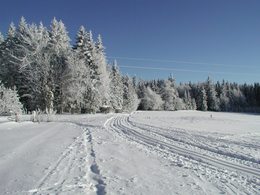
panoramic view: Great panorama
Paths covering:
snow
powered by TOURDATA
Trail not in operation
You can enter this track either in Kollerschlag or in Nebelberg.
For information on the snow conditions please call the tourist office (+43 (0)5 789 100) or go online.
Starting point:
Kollerschlag, Bauhof or Flenkelmühle
Vordernebelberg, Ramlhof inn
Nebelberg, parish hall
Mistlberg track : 7 km | P | intermediate-hard
Starting point:
Kollerschlag, Bauhof
Mistlberg, fire station
Kollerado track: 2.5 km | P+S | easy
Starting point:
Kollerschlag, Bauhof
Nebelberg loop track: 16 km | P+S | intermediate
Starting point:
Kollerschlag, Bauhof or Flenkelmühle
Vordernebelberg, Ramlhof inn
Stift am Grenzbach, Jagawirt inn
Nebelberg, parish hall
P = parallel track
S = skating track
Get your free cross-country skiing map!
Most economical season
- Deep winter
Please get in touch for more information.
Markt 15
4154 Kollerschlag
Phone +43 7287 8155
Fax machine +43 7287 8155 - 15
E-Mail boehmerwald@muehlviertel.at
Web www.kollerschlag.at
http://www.kollerschlag.at
You can also visit us on
Visit us on Facebook Visit us on Instagram Visit our videochannel on YouTubeInteractive elevation profile
Create PDF
Tour-Details
Path number: 9
Starting place: 4154 Kollerschlag
Destination: 4154 Kollerschlag
duration: 1h 30m
length: 11,0 km
Altitude difference (uphill): 98m
Altitude difference (downhill): 101m
Lowest point: 652m
Highest point: 723m
difficulty: medium
condition: medium
panoramic view: Great panorama
Paths covering:
snow
powered by TOURDATA