

Petersbergrunde


- Flatly
Interactive elevation profile
Create PDF
Tour-Details
Starting place: 4172 St. Johann am Wimberg
Destination: 4172 St. Johann am Wimberg
duration: 2h 38m
length: 9,4 km
Altitude difference (uphill): 171m
Altitude difference (downhill): 176m
Lowest point: 673m
Highest point: 808m
difficulty: medium
condition: medium
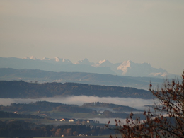
panoramic view: Great panorama
Paths covering:
Asphalt, Gravel, Hiking trail
powered by TOURDATA
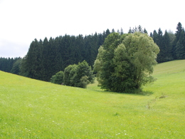
This hiking trail leads past large farms with marvellous views of the "Steinerne Mühl" valley and the Czech and Bavarian borders.
With the free outdooractive app, you can hike the trail using navigation.
Most economical season
- Spring
- Summer
- Autumn
- Early winter
Please get in touch for more information.
St. Johann 10
4172 St. Johann am Wimberg
Phone +43 7217 7155
E-Mail gemeinde@stjohannamwimberg.at
Web www.stjohannamwimberg.at
https://www.stjohannamwimberg.at
You can also visit us on
Visit us on Facebook Visit us on Instagram Visit our videochannel on YouTubeInteractive elevation profile
Create PDF
Tour-Details
Starting place: 4172 St. Johann am Wimberg
Destination: 4172 St. Johann am Wimberg
duration: 2h 38m
length: 9,4 km
Altitude difference (uphill): 171m
Altitude difference (downhill): 176m
Lowest point: 673m
Highest point: 808m
difficulty: medium
condition: medium
panoramic view: Great panorama
Paths covering:
Asphalt, Gravel, Hiking trail
powered by TOURDATA