

Kleiner Hopfensteig


- Flatly
Interactive elevation profile
Create PDF
Tour-Details
Starting place: 4116 St. Ulrich im Mühlkreis
Destination: 4116 St. Ulrich im Mühlkreis
duration: 1h 27m
length: 5,2 km
Altitude difference (uphill): 92m
Altitude difference (downhill): 100m
Lowest point: 544m
Highest point: 611m
difficulty: easy
condition: medium
panoramic view: Individual Views
Paths covering:
Hiking trail
powered by TOURDATA
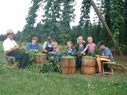
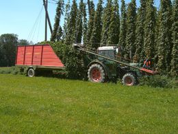
Characteristic of hops are the trellises with a height of approx. 7 m, which characterise the landscape in HansBergLand. Such trellises can be admired along the small hop trail. The farmers concerned are happy to provide further information about hop growing. During the hop harvest (September/October), you can also watch the harvest directly.
Starting point: HopfenErlebnisHof or Gasthaus Lang
Trail surface: tarmac, forest and meadow path
With the free outdooractive app, you can hike the trail using navigation.
Starting point: HopfenErlebnisHof or Gasthaus Lang
Trail surface: tarmac, forest and meadow path
With the free outdooractive app, you can hike the trail using navigation.
Most economical season
- Spring
- Summer
- Autumn
Please get in touch for more information.
Ulrichstraße 4
4116 St. Ulrich im Mühlkreis
Phone +43 5 07263 - 200
E-Mail boehmerwald@muehlviertel.at
Web www.muehlviertel.at/
https://www.muehlviertel.at/
")
")
")
Interactive elevation profile
Create PDF
Tour-Details
Starting place: 4116 St. Ulrich im Mühlkreis
Destination: 4116 St. Ulrich im Mühlkreis
duration: 1h 27m
length: 5,2 km
Altitude difference (uphill): 92m
Altitude difference (downhill): 100m
Lowest point: 544m
Highest point: 611m
difficulty: easy
condition: medium
panoramic view: Individual Views
Paths covering:
Hiking trail
powered by TOURDATA