


Schwemmkanal/Bayrische Au circuit


- culinary interesting
- culturally interesting
- Flatly
- Possible accommodation
Interactive elevation profile
Create PDF
Tour-Details
Path number: 42
Starting place: 4160 Aigen-Schlägl
Destination: 4160 Aigen-Schlägl
duration: 3h 30m
length: 12,5 km
Altitude difference (uphill): 189m
Altitude difference (downhill): 187m
Lowest point: 729m
Highest point: 883m
difficulty: medium
condition: medium
panoramic view: Great panorama
Paths covering:
Asphalt, Path / trail, Hiking trail
powered by TOURDATA
Following the trail of the Schwarzenbergischer Schwemmkanal (Schwarzenberg log flume) in the Böhmerwald (Bohemian Forest) holiday region!
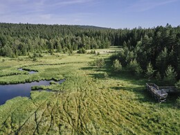
A very beautiful, idyllic tour that leads to two renovated locks of the Schwarzenberg Schwemmkanal and into the Spirkenhochmoor Bayrische Au.
0 km The hike starts at the Oberhaag car park (170 m further on as the Landhotel Haagerhof, Diendorf 20, 4160 Aigen-Schlägl, access via Krumauerstraße). Follow the road towards Grünwald for 650 m, turn right into the road again. Continue along the road, which turns into a forest path, until you reach the...
2.6 km ...Schrollenbachschleuse. The alluvial canal has been restored at this point. Alluvial flooding takes place here during the summer months.
Dates at www.boehmerwald.at.
This canal, which was opened in 1790 and was in operation for around 100 years, was used to float around 8 million cubic metres of timber from the Bohemian Forest to the Große Mühl and on to Vienna on rafts. Following the alluvial canal for a while, turn left onto the forest path down to the...
4.1 km ...tarmac road that leads from Oberhaag to the border (access to the ferry). Continue left, however, and after 200 metres turn right again onto the forest road and follow the Bayrische Au nature trail. Follow the signs and the red-white-red markings until you reach the nature trail in the...
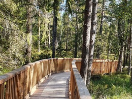
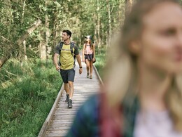
6.0 km ...Hochmoorgebiet Bayrische Au. Then follow the wooden footbridge. The information boards provide you with interesting facts about the raised bog area. Enjoy the view of the Vltava reservoir towards the Czech Republic from the viewing platform. Continue following the signs for the Bayrische Au nature trail and the red-white-red markings and then "Schwemmkanal / Bayrische Au Runde Nr. 42" again. Now continue along beautiful forest paths until you reach the...
10.4 km ...Iglbachschleuse . In the summer months, floating demonstrations are also held here. Cross the double bridge, continue on forest paths and forest roads until you reach the...
12.7 km ...starting point Oberhaag.
request our hiking map for EUR 3.00
For more information about the Schwarzenergischer Schwemmkanal, here.
With the free outdooractive app, you can hike the trail using navigation.
A very beautiful, idyllic tour that leads to two renovated locks of the Schwarzenberg Schwemmkanal and into the Spirkenhochmoor Bayrische Au.
0 km The hike starts at the Oberhaag car park (170 m further on as the Landhotel Haagerhof, Diendorf 20, 4160 Aigen-Schlägl, access via Krumauerstraße). Follow the road towards Grünwald for 650 m, turn right into the road again. Continue along the road, which turns into a forest path, until you reach the...
2.6 km ...Schrollenbachschleuse. The alluvial canal has been restored at this point. Alluvial flooding takes place here during the summer months.
Dates at www.boehmerwald.at.
This canal, which was opened in 1790 and was in operation for around 100 years, was used to float around 8 million cubic metres of timber from the Bohemian Forest to the Große Mühl and on to Vienna on rafts. Following the alluvial canal for a while, turn left onto the forest path down to the...
4.1 km ...tarmac road that leads from Oberhaag to the border (access to the ferry). Continue left, however, and after 200 metres turn right again onto the forest road and follow the Bayrische Au nature trail. Follow the signs and the red-white-red markings until you reach the nature trail in the...
6.0 km ...Hochmoorgebiet Bayrische Au. Then follow the wooden footbridge. The information boards provide you with interesting facts about the raised bog area. Enjoy the view of the Vltava reservoir towards the Czech Republic from the viewing platform. Continue following the signs for the Bayrische Au nature trail and the red-white-red markings and then "Schwemmkanal / Bayrische Au Runde Nr. 42" again. Now continue along beautiful forest paths until you reach the...
10.4 km ...Iglbachschleuse . In the summer months, floating demonstrations are also held here. Cross the double bridge, continue on forest paths and forest roads until you reach the...
12.7 km ...starting point Oberhaag.
request our hiking map for EUR 3.00
For more information about the Schwarzenergischer Schwemmkanal, here.
With the free outdooractive app, you can hike the trail using navigation.
Starting point: Oberhaag car park, Aigen-Schlägl.
Destination: Oberhaag car park, Aigen-Schlägl.
further information:
- culinary interesting
- Flatly
- Possible accommodation
- Board possible
Accessibility / arrival
by car:
from Linz – B127 to Rohrbach – Öpping - Aigen-Schlägl
from Passau – Breitenberg border checkpoint – Klaffer – Ulrichsberg – Aigen-Schlägl
from the Czech Republic – Zadni Zvonkova/Schöneben border checkpoint – Ulrichsberg – Aigen-Schlägl
Most economical season
- Spring
- Summer
- Autumn
Please get in touch for more information.
Hauptstraße 2
4160 Aigen-Schlägl
Phone +43 5 7890 - 100
Fax machine +43 5 7890 - 115
E-Mail info@boehmerwald.at
Web www.boehmerwald.at
https://www.boehmerwald.at
You can also visit us on
Visit us on Facebook Visit us on Twitter")
")
")
Interactive elevation profile
Create PDF
Tour-Details
Path number: 42
Starting place: 4160 Aigen-Schlägl
Destination: 4160 Aigen-Schlägl
duration: 3h 30m
length: 12,5 km
Altitude difference (uphill): 189m
Altitude difference (downhill): 187m
Lowest point: 729m
Highest point: 883m
difficulty: medium
condition: medium
panoramic view: Great panorama
Paths covering:
Asphalt, Path / trail, Hiking trail
powered by TOURDATA