


Lipno Reservoir bicycle route


- culturally interesting
- Flatly
- Possible accommodation
Interactive elevation profile
Create PDF
Tour-Details
Path number: 800
Starting place: 4160 Aigen-Schlägl
Destination: 4160 Aigen-Schlägl
duration: 4h 0m
length: 42,0 km
Altitude difference (uphill): 288m
Altitude difference (downhill): 280m
Lowest point: 577m
Highest point: 856m
difficulty: medium
condition: medium
panoramic view: Great panorama
Paths covering:
Asphalt, Gravel
powered by TOURDATA
Cross-border bike tour (take travel document with you)! 0 km From the Aigen-Schlägl market square cycle along the road between Hotel Almesberger and the church, leave the railway station on your right and cycle along a rather flat path to Baureith. Turn left there and cycle parallel to the R5 provincial cycle path via Wurmbrand (short climb) and Günterreith to...
6.6 km to St. Oswald. Turn left at the village well and car park and then take the bend to the right. At the monument to displaced persons, continue left uphill to the former customs house.
8 km Now you reach the border with the Czech Republic. Past the "Connect it" sculpture and an information board about the "Iron Curtain", always follow the road to...
10.8 km Rosenhügel/Koranda. (Large crossroads, shelter hut). At this point, the Schwarzenberg Alluvial Canal crosses the main European watershed - 220 years ago, this construction was a technical masterpiece. You cross the alluvial canal and continue straight downhill. At the crossroads in the hollow, cycle left to the banks of the...
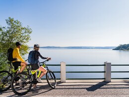
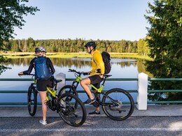
14.7 km Vltava reservoir (Lipno reservoir). In 1957, the Vltava was dammed near Lipno for a hydroelectric power station. Entire villages could be seen sinking into the lake here. You reach a dam and can see the Bavarian Au on the left. The road now leads to a crossroads. Here you cycle straight on to Přední Zvonková The path leads hilly near the reservoir to a crossroads...
25 km where you turn left to Přední Zvonková (Vorderglöckelberg). Immediately after the village, turn left again...
26.7 km to Zadní Zvonková Back on the tarmac road, leave it to the east and cycle along the alluvial canal cycle path to the border crossing at the Rotbach lock. At the junction with the tarmac road, continue left and you will soon reach...
29 km Sonnenwald. In its heyday in the mid-19th century, the glassworks in Sonnenwald supplied high-quality utility and decorative glass to the imperial city of Vienna. In 1854 alone, 33 tonnes of glass were produced here. At one time, up to 140 people lived here - that is hardly imaginable today. The location of the glassworks was above the canal and is no longer recognisable today. You follow the canal road and come across more locks and the "7 Ravens" sculpture.
36.1 km Cycle to the Schrollenbach lock. After around 200 metres, turn right and leave the canal. Climbing slightly, you reach the tarmac district road and continue right to...
38.5 km Oberhaag (possibility to visit the Schwedenschanzen). From here, a steep descent leads back to the...
42 km starting point Aigen-Schlägl.
Request our cycle map for EUR 3.00!
Use the free outdooractive app to navigate the route.
6.6 km to St. Oswald. Turn left at the village well and car park and then take the bend to the right. At the monument to displaced persons, continue left uphill to the former customs house.
8 km Now you reach the border with the Czech Republic. Past the "Connect it" sculpture and an information board about the "Iron Curtain", always follow the road to...
10.8 km Rosenhügel/Koranda. (Large crossroads, shelter hut). At this point, the Schwarzenberg Alluvial Canal crosses the main European watershed - 220 years ago, this construction was a technical masterpiece. You cross the alluvial canal and continue straight downhill. At the crossroads in the hollow, cycle left to the banks of the...
14.7 km Vltava reservoir (Lipno reservoir). In 1957, the Vltava was dammed near Lipno for a hydroelectric power station. Entire villages could be seen sinking into the lake here. You reach a dam and can see the Bavarian Au on the left. The road now leads to a crossroads. Here you cycle straight on to Přední Zvonková The path leads hilly near the reservoir to a crossroads...
25 km where you turn left to Přední Zvonková (Vorderglöckelberg). Immediately after the village, turn left again...
26.7 km to Zadní Zvonková Back on the tarmac road, leave it to the east and cycle along the alluvial canal cycle path to the border crossing at the Rotbach lock. At the junction with the tarmac road, continue left and you will soon reach...
29 km Sonnenwald. In its heyday in the mid-19th century, the glassworks in Sonnenwald supplied high-quality utility and decorative glass to the imperial city of Vienna. In 1854 alone, 33 tonnes of glass were produced here. At one time, up to 140 people lived here - that is hardly imaginable today. The location of the glassworks was above the canal and is no longer recognisable today. You follow the canal road and come across more locks and the "7 Ravens" sculpture.
36.1 km Cycle to the Schrollenbach lock. After around 200 metres, turn right and leave the canal. Climbing slightly, you reach the tarmac district road and continue right to...
38.5 km Oberhaag (possibility to visit the Schwedenschanzen). From here, a steep descent leads back to the...
42 km starting point Aigen-Schlägl.
Request our cycle map for EUR 3.00!
Use the free outdooractive app to navigate the route.
Starting point: Marketplace.
Destination: Marketplace.
further information:
- Flatly
- Possible accommodation
- Board possible
Most economical season
- Spring
- Summer
- Autumn
Please get in touch for more information.
Hauptstraße 2
4160 Aigen-Schlägl
Phone +43 5 7890 - 100
Fax machine +43 5 7890 - 115
E-Mail info@boehmerwald.at
Web www.boehmerwald.at/
https://www.boehmerwald.at/
You can also visit us on
Visit us on Facebook Visit us on Instagram Visit our videochannel on YouTube")
")
")
")
")

Interactive elevation profile
Create PDF
Tour-Details
Path number: 800
Starting place: 4160 Aigen-Schlägl
Destination: 4160 Aigen-Schlägl
duration: 4h 0m
length: 42,0 km
Altitude difference (uphill): 288m
Altitude difference (downhill): 280m
Lowest point: 577m
Highest point: 856m
difficulty: medium
condition: medium
panoramic view: Great panorama
Paths covering:
Asphalt, Gravel
powered by TOURDATA